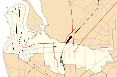
| Dudley Park Adelaide, South Australia | |||||||||||||||
|---|---|---|---|---|---|---|---|---|---|---|---|---|---|---|---|
 Dudley Park Railway Station | |||||||||||||||
| Coordinates | 34°52′48″S 138°34′48″E / 34.880°S 138.580°E | ||||||||||||||
| Population | 670 (SAL 2021)[1] | ||||||||||||||
| Established | 1909[2] | ||||||||||||||
| Postcode(s) | 5008[3] | ||||||||||||||
| Location | 3 km (2 mi) north of Adelaide city centre | ||||||||||||||
| LGA(s) | City of Port Adelaide Enfield | ||||||||||||||
| State electorate(s) | Croydon[4] | ||||||||||||||
| Federal division(s) | Adelaide[5] | ||||||||||||||
| |||||||||||||||
Dudley Park, is a suburb of Adelaide, South Australia, located approximately 3 kilometres north-west of the CBD.[6] The suburb is bordered by Regency Road (north), Simpson Avenue (south), the Adelaide-Gawler railway line (east), and a line directly north–south from the Harrison Road-Simpson Avenue intersection to Regency Road (west).
The Dudley Park Cemetery is located within the suburb at the corner of Simpson Avenue and Exeter Terrace.
Two railway stations border the suburb, Islington railway station and Dudley Park railway station.
- ^ Australian Bureau of Statistics (28 June 2022). "Dudley Park (SA) (suburb and locality)". Australian Census 2021 QuickStats. Retrieved 28 June 2022.
- ^ Cite error: The named reference
Manningwas invoked but never defined (see the help page). - ^ Cite error: The named reference
propertybrowserwas invoked but never defined (see the help page). - ^ "District of Croydon map". ELECTORAL COMMISSION SA. 2014. Retrieved 3 December 2015.
- ^ "Federal Electoral Division of Adelaide" (PDF). Australian Electorate Commission. 16 December 2011. Retrieved 3 December 2015.
- ^ 2003 Adelaide Street Directory, 41st Edition. UBD (A Division of Universal Press Pty Ltd). 2003. ISBN 0-7319-1441-4.
