| Dunderland Valley | |
|---|---|
| Dunderlandsdalen (Norwegian) Dunndaravuobme (Lule Sami) | |
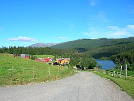
 View of the valley at Eiterå | |
 Interactive map of the valley | |
| Length | 80 kilometres (50 mi) |
| Geology | |
| Type | River valley |
| Geography | |
| Location | Nordland, Norway |
| Coordinates | 66°23′01″N 14°34′04″E / 66.38361°N 14.56778°E |
The Dunderland Valley[1][2][3] (Norwegian: Dunderlandsdalen, Lule Sami: Dunndaravuobme) is a valley in Rana Municipality in Nordland county, Norway. It reaches from just below the eastern Saltfjellet plateau about 8 miles (13 km) south of the Arctic Circle. The mountain Bolna is situated in the uppermost boundary of the valley which then proceeds to the southwest all the way down to the Ranfjorden. Some of the minor side valleys include Plurdalen, Røvassdalen, Bjøllådalen, Grønfjelldalen and Virvassdalen. The valley also includes several villages such as Krokstrand, Bjøllånes, Storvoll, Dunderland, Eiterå, Nevernes, Storforshei, Nevermoen and Røssvoll.[4]


The European route E6 highway passes through the Dunderland Valley, following the Ranelva river. The Illhøllia Tunnel on the E6 highway, between Nevermoen and Røssvoll, was opened in 2002. The Nordland Line also follows the river through the valley. Today, the valley only houses a small number of people, and it has two stations on the Nordland Line: Dunderland Station and Bolna Station.
- ^ Minerals Yearbook, 2005, V. 3, Area Reports, International, Latin America and Canada, vol. 3. 2007. Washington, DC: United States Department of the Interior, p. 284.
- ^ Boyns, Trevor. 1997. The Steel Industry: The Coming of Mass Steel Production, 1870-1914. London: I.B. Tauris Publishers, p. 75.
- ^ Jonung, Lars, & Rolf Ohlsson. 1997. The Economic Development of Sweden since 1870. Cheltenham, UK: Edward Elgar, p. 372.
- ^ Store norske leksikon. "Dunderlandsdalen" (in Norwegian). Retrieved 2011-12-13.