| Dundry | |
|---|---|
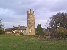
 Dundry church | |
Location within Somerset | |
| Population | 829 [1] |
| OS grid reference | ST555665 |
| Unitary authority | |
| Ceremonial county | |
| Region | |
| Country | England |
| Sovereign state | United Kingdom |
| Post town | BRISTOL |
| Postcode district | BS41 |
| Dialling code | 0117 |
| Police | Avon and Somerset |
| Fire | Avon |
| Ambulance | South Western |
| UK Parliament | |


Dundry is a village and civil parish, situated on Dundry Hill in the northern part of the Mendip Hills, between Bristol and the Chew Valley Lake, in the English county of North Somerset, previously Somerset. The parish includes the hamlets of Maiden Head and East Dundry. The parish had a 2011 population of 829.[1]
The village lies on the route of the Monarch's Way long-distance footpath. It is a popular destination for the people of Bristol as it is known for its panoramic views of the city.
- ^ a b "2011 Census Profile". North Somerset Council. Archived from the original (Excel) on 4 January 2014. Retrieved 4 January 2014.
