Dundurn | |
|---|---|
Town | |
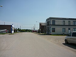
 Dundurn's Business District: 2nd Street | |
Location of Dundurn in Saskatchewan | |
| Coordinates: 51°49′N 106°30′W / 51.817°N 106.500°W | |
| Country | Canada |
| Province | Saskatchewan |
| Rural Municipalities (R.M.) | Dundurn |
| Post office Founded in NWT | 1894-09-01 |
| Village | 1905 |
| Town | 1980 |
| Government | |
| • Mayor | Curtis Boyes |
| Area | |
| • Land | .88 km2 (0.34 sq mi) |
| Population (2021) | |
• Total | 675 |
| • Density | 736.88/km2 (1,908.5/sq mi) |
| • Summer (DST) | CST |
| Postal code | S0K 1K0 |
| Website | Official website |
| [1][2][3][4] | |
Dundurn is a town of 647 residents surrounded by the RM of Dundurn No. 314, in the Canadian province of Saskatchewan. Dundurn is located on Highway 11, or Louis Riel Trail, in central Saskatchewan, about 42 km south of Saskatoon. As well as being an agricultural town, it is a bedroom community for both Saskatoon and Canadian Forces Detachment Dundurn, which is located 6 kilometres (4 mi) north of town and is a detachment of 17 Wing Winnipeg.
The town is situated between Highway 11 and the north end of Brightwater Lake, with Swamp Lake[5] directly north of town. Dundurn is run under a mayor-council form of civic governance.
- ^ National Archives, Archivia Net. "Post Offices and Postmasters". Archived from the original on October 6, 2006. Retrieved May 26, 2007.
- ^ Government of Saskatchewan, MRD Home. "Municipal Directory System". Archived from the original on January 15, 2016. Retrieved July 6, 2014.
- ^ Canadian Textiles Institute. (2005). "CTI Determine your provincial constituency". Archived from the original on September 11, 2007. Retrieved May 26, 2007.
- ^ Commissioner of Canada Elections, Chief Electoral Officer of Canada (2005). "Elections Canada On-line". Archived from the original on April 21, 2007. Retrieved April 24, 2007.
- ^ Government of Canada, Natural Resources Canada. "Place names - Swamp Lake". www4.rncan.gc.ca.

