| Dunedoo New South Wales | |||||||||
|---|---|---|---|---|---|---|---|---|---|
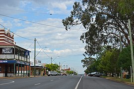
 Bolaro Street (Castlereagh Highway), the main street of Dunedoo, 2017 | |||||||||
| Coordinates | 32°01′0″S 149°24′0″E / 32.01667°S 149.40000°E | ||||||||
| Population | 1,021 (2021 census)[1] | ||||||||
| Established | 1840s | ||||||||
| Postcode(s) | 2844 | ||||||||
| Elevation | 399 m (1,309 ft) | ||||||||
| Location | |||||||||
| LGA(s) | Warrumbungle Shire | ||||||||
| County | Bligh | ||||||||
| State electorate(s) | Upper Hunter | ||||||||
| Federal division(s) | Parkes | ||||||||
| |||||||||
Dunedoo (/ˈdʌniduː/ DUN-ee-doo) is a village of 1,021 inhabitants[1] situated within the Warrumbungle Shire of central western New South Wales, Australia. Dunedoo is well known to Australian travellers due to its distinctive name (Dunny is a colloquial Australian word for a toilet). The name is actually derived from a local Aboriginal word meaning "swan",[2] which are commonly found in the area's lagoons.
The town is located on the north-western edges of the Sydney basin.[3]
- ^ a b Australian Bureau of Statistics (28 June 2022). "Dunedoo (L) (Urban Centre/Locality)". 2021 Census QuickStats. Retrieved 5 January 2019.
 Material was copied from this source, which is available under a Creative Commons Attribution 4.0 International License.
- ^ "Dunedoo". Geographical Names Register (GNR) of NSW. Geographical Names Board of New South Wales. Retrieved 5 August 2013.
- ^ http://www.dpi.nsw.gov.au/__data/assets/image/0007/96847/20758.gif Archived 17 September 2011 at the Wayback Machine [bare URL image file]
