Dunlap, Indiana | |
|---|---|
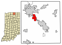
 Location of Dunlap in Elkhart County, Indiana. | |
| Coordinates: 41°37′40″N 85°55′12″W / 41.62778°N 85.92000°W | |
| Country | United States |
| State | Indiana |
| County | Elkhart |
| Area | |
• Total | 4.93 sq mi (12.76 km2) |
| • Land | 4.92 sq mi (12.74 km2) |
| • Water | 0.01 sq mi (0.03 km2) |
| Elevation | 778 ft (237 m) |
| Population (2020) | |
• Total | 6,442 |
| • Density | 1,310.15/sq mi (505.84/km2) |
| Time zone | UTC-5 (Eastern (EST)) |
| • Summer (DST) | UTC-4 (EDT) |
| ZIP code | 46517, 46516, 46526 |
| Area code | 574 |
| FIPS code | 18-19072[3] |
| GNIS feature ID | 2392982[2] |
Dunlap is a census-designated place (CDP) in Elkhart County, Indiana, United States. The population was 6,235 at the 2010 census.[4] Once a small farming community, by the 1980s it had become a suburb of Elkhart and Goshen, Indiana. Most of the town was destroyed by two violent F4 tornadoes during the Palm Sunday Tornado Outbreak on April 11, 1965.
- ^ "2020 U.S. Gazetteer Files". United States Census Bureau. Retrieved March 16, 2022.
- ^ a b U.S. Geological Survey Geographic Names Information System: Dunlap, Indiana
- ^ "U.S. Census website". United States Census Bureau. Retrieved January 31, 2008.
- ^ "Profile of General Population and Housing Characteristics: 2010 Demographic Profile Data (DP-1): Dunlap CDP, Indiana". United States Census Bureau. Retrieved July 12, 2012.