Durant, Mississippi | |
|---|---|
 Train station in Durant | |
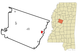
 Location of Durant, Mississippi | |
| Coordinates: 33°4′35″N 89°51′23″W / 33.07639°N 89.85639°W | |
| Country | United States |
| State | Mississippi |
| County | Holmes |
| Government | |
| • Mayor | John Haynes |
| Area | |
• Total | 2.26 sq mi (5.86 km2) |
| • Land | 2.24 sq mi (5.80 km2) |
| • Water | 0.02 sq mi (0.06 km2) |
| Elevation | 259 ft (79 m) |
| Population (2020) | |
• Total | 2,231 |
| • Density | 995.98/sq mi (384.59/km2) |
| Time zone | UTC-6 (Central (CST)) |
| • Summer (DST) | UTC-5 (CDT) |
| ZIP code | 39063 |
| Area code | 662 |
| FIPS code | 28-20500 |
| GNIS feature ID | 0669521 |
| Website | https://www.cityofdurantms.com/ |
Durant is a city near the central eastern border of Holmes County, Mississippi, United States, and Big Black River. The town was founded in 1858 as a station on the Mississippi Central Railroad, later part of the Illinois Central. Durant was named for Louis Durant, a Choctaw chief who had lived on this site before the United States undertook Indian Removal in the 1830s, forcing him and most of the Choctaw to Indian Territory west of the Mississippi River.
The population of the rural city was 2,673 at the 2010 census,[2] down from 2,932 at the 2000 census.
About 3 miles away is the Castalian Springs Hotel, believed in 2020 to be the only surviving such spa structure in the state.[3] A dozen mineral springs resorts were identified in the Works Progress Administration (WPA) Guide to Mississippi (1938), written during the Great Depression. Such springs were believed to have healing properties.
- ^ "2020 U.S. Gazetteer Files". United States Census Bureau. Retrieved July 24, 2022.
- ^ "Geographic Identifiers: 2010 Census Summary File 1 (G001): Durant city, Mississippi". American Factfinder. U.S. Census Bureau. Archived from the original on February 13, 2020. Retrieved August 17, 2017.
- ^ Cite error: The named reference
graysonwas invoked but never defined (see the help page).

