Județul Durostor | |
|---|---|
County (Județ) | |
 | |
| Country | |
| Historic region | Southern Dobruja |
| County seat (Reședință de județ) | Dârstor |
| Established | After the Treaty of Bucharest (1913) |
| Ceased to exist | Administrative and Constitutional Reform in 1938 |
| Area | |
| • Total | 3,226 km2 (1,246 sq mi) |
| Population (1930) | |
| • Total | 211,433 |
| • Density | 66/km2 (170/sq mi) |
| Time zone | UTC+2 (EET) |
| • Summer (DST) | UTC+3 (EEST) |
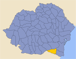
Durostor County was a county (județ) of the Kingdom of Romania, in Southern Dobruja, with the seat at Dârstor.
The county was located in the south-eastern part of Greater Romania, in the southern Dobrogea region, known as Cadrilater. Currently the territory of the former county is split between Bulgaria and Romania; in Bulgaria, the former county's territory belongs to Silistra Province, the eastern part of the former county remained within territory of Romania constituting the territory around Ostrov in today's Constanța County.
The county consisted of 4 districts (plăși): Accadânlar, Curtbunar, Silistra, and Turtucaia. The county was neighbored by the counties of Ilfov and Ialomița to the north, Caliacra and Constanța to the east, and the Kingdom of Bulgaria to the south.
