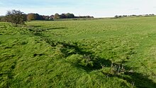
 Southern Wall of Durrington Walls | |
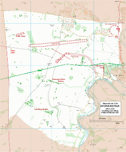
Map showing Woodhenge and Durrington Walls within the Stonehenge section of the Stonehenge and Avebury World Heritage Site | |
| Location | OS SU150437 |
|---|---|
| Region | Wiltshire |
| Coordinates | 51°11′33″N 1°47′15″W / 51.1925°N 1.7875°W |
| Type | henge |
| History | |
| Periods | Neolithic |
| Site notes | |
| Excavation dates | 1966-7, 2003– |
| Archaeologists | G.J. Wainwright, Stonehenge Riverside Project |
| Condition | eroded banks and ditch |
| Public access | Yes |
| Website | National Trust |
| Designated | 1986[1] |
| Reference no. | 373 |
| Designated | 1929 |
| Reference no. | 1009133[2] |
Durrington Walls is the site of a large Neolithic settlement and later henge enclosure located in the Stonehenge World Heritage Site in England. It lies 2 miles (3.2 km) north-east of Stonehenge in the parish of Durrington, just north of Amesbury in Wiltshire. The henge is the second-largest Late Neolithic palisaded enclosure known in the United Kingdom, after Hindwell in Wales.[3]
Between 2004 and 2006, excavations on the site by a team led by the University of Sheffield revealed seven houses. It has been suggested that the settlement may have originally had up to 1,000 houses and perhaps 4,000 people, if the entire enclosed area was used. The site was settled for about 500 years, starting sometime between c. 2800 and 2100 BC.[4]
The site may have been the largest settlement in northern Europe for a brief period.[5][6][7] From 2010 to 2014, a combination of new technology and excavations revealed a 500-metre-diameter (1,600 ft) henge constructed largely of wooden posts. Evidence suggests that this complex was a complementary monument to Stonehenge.[8]
In 2020, a geophysical survey uncovered a number of pits, some natural sink holes and others apparently modified to hold massive timbers, interpreted as belonging to a 1.2-mile-wide (1.9 km) circle or circuit of 10-metre (33 ft) pits of Neolithic age. If this interpretation is correct, this would be Britain's largest prehistoric monument.[9]
- ^ Centre, UNESCO World Heritage. "Stonehenge, Avebury and Associated Sites". UNESCO World Heritage Centre.
- ^ Historic England. "Henge monuments at Durrington Walls and Woodhenge, a round barrow cemetery, two additional round barrows and four settlements (1009133)". National Heritage List for England. Retrieved 24 January 2015.
- ^ Bartos, Nick (10 October 2016). "Rethinking Durrington Walls: a long-lost monument revealed". Current Archeology. 320. Retrieved 28 August 2020.
- ^ Craig, O.E., Shillito, L.M., Albarella, U., Viner-Daniels, S., Chan, B., Cleal, R., Ixer, R., Jay, M., Marshall, P., Simmons, E. and Wright, E., 2015. "Feeding Stonehenge: cuisine and consumption at the Late Neolithic site of Durrington Walls". Antiquity, 89(347), pp. 1096–1109.
- ^ "Stonehenge builders travelled from far, say researchers". BBC News. 9 March 2013.
- ^ Price, Siân (5 November 2007). "Stonehenge's huge support settlement". BBC. Retrieved 11 April 2018.
- ^ "Huge Settlement Unearthed Near Stonehenge World Heritage Site". UNESCO World Heritage Centre. 13 February 2007. Retrieved 11 April 2018.
- ^ Wilford, John Noble (30 January 2007). "Traces of Ancient Village Found Near Stonehenge". The New York Times. Retrieved 11 April 2018.
- ^ Gaffney, Vincent; Baldwin, Eamonn; Bates, Martin; Bates, C. Richard; Gaffney, Christopher; Hamilton, Derek; Kinnaird, Tim; Neubauer, Wolfgang; Yorston, Ronald; Allaby, Robin; Chapman, Henry; Garwood, Paul; Löcker, Klaus; Hinterleitner, Alois; Sparrow, Tom; Trinks, Immo; Wallner, Mario; Leivers, Matthew (21 June 2020). "A Massive, Late Neolithic Pit Structure associated with Durrington Walls Henge". Internet Archaeology. doi:10.11141/ia.55.4. hdl:10454/18007. Retrieved 23 June 2020.
