| Duwamish River Lushootseed: dxʷdəw | |
|---|---|
 The lower Duwamish Waterway and the First Avenue South Bridge (State Route 99), looking north. Slips 1, 2, and 3 can be seen on the eastern bank. Kellogg Island is the crescent-shaped island in the upper right portion. Terminal 115 is located in the central portion | |
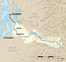
 Map of the Duwamish/Green River watershed with the Duwamish highlighted | |
| Location | |
| Country | United States |
| State | Washington |
| Cities | Seattle, Tukwila |
| Physical characteristics | |
| Source | Green River |
| Mouth | Elliott Bay |
| Length | 12 mi (19 km) |
| Discharge | |
| • location | Elliott Bay |
The Duwamish River (Lushootseed: dxʷdəw)[1] is the name of the lower 12 miles (19 km) of Washington state's Green River. Its industrialized estuary is known as the Duwamish Waterway. Although heavily polluted, it is an important habitat for the wildlife. Important to the Duwamish people, the Duwamish Longhouse and Cultural Center is on the west bank of the river and several parks have indigenous Lushootseed names .
- ^ Bates, Dawn; Hess, Thom; Hilbert, Vi (1994). Lushootseed Dictionary. Seattle: University of Washington Press. ISBN 978-0-295-97323-4. OCLC 29877333.