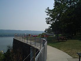
| Eagle Point Park | |
|---|---|
 View of the Mississippi River from Eagle Point Park | |
 | |
| Type | Public park |
| Location | Dubuque, Iowa |
| Area | 164 acres (0.66 km2)[1] |
| Created | May 1909 |
| Operated by | City of Dubuque |
| Open | May to October |
Eagle Point Park Historic District | |
 Bridge Complex (1935) | |
| Coordinates | 42°32′26″N 90°39′03″W / 42.54056°N 90.65083°W |
| Architect | Charles Mulford Robinson Charles Nassau Lowrie Alfred Caldwell, et al. |
| Architectural style | Prairie School |
| NRHP reference No. | 100001834[2] |
| Added to NRHP | November 27, 2017 |
Eagle Point Park is a 164-acre (0.66 km2) public park[1] located in the northeast corner of the city of Dubuque, Iowa, United States. Eagle Point is mostly situated on a bluff that overlooks the Mississippi River and the Lock and Dam No. 11.[3] The park is owned and operated by the city of Dubuque. It was listed as a historic district on the National Register of Historic Places in 2017.[2] At the time of its nomination it contained 34 resources, which included 14 contributing buildings, seven contributing sites, five structures, five objects, two non-contributing buildings, and two non-contributing structures.[4]
- ^ a b "Eagle Point Park, Dubuque County". Geographic Names Information System. United States Geological Survey, United States Department of the Interior. April 30, 1979. Retrieved July 26, 2015.
- ^ a b "National Register of Historic Places Program: Weekly List". National Park Service. Retrieved December 4, 2017.
- ^ Shaffer, James L.; Tigges, John T. (2001). Dubuque, Iowa. Arcadia Publishing. p. 81. ISBN 9780738518510. Retrieved July 26, 2015.
- ^ Dr. Julie Schlarman. "Eagle Point Park Historic District". National Park Service. Retrieved December 4, 2017.

