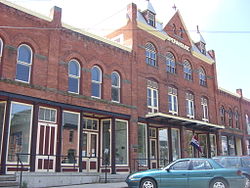
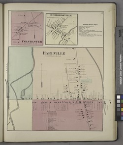
Earlville, New York | |
|---|---|
 Earlville Opera House | |
 Earlville in 1875 | |
| Coordinates: 42°44′28″N 75°32′38″W / 42.74111°N 75.54389°W | |
| Country | United States |
| State | New York |
| Counties | Madison, Chenango |
| Towns | Hamilton, Sherburne |
| Area | |
• Total | 1.08 sq mi (2.80 km2) |
| • Land | 1.08 sq mi (2.80 km2) |
| • Water | 0.00 sq mi (0.00 km2) |
| Elevation | 1,099 ft (335 m) |
| Population (2020) | |
• Total | 774 |
| • Density | 716.00/sq mi (276.49/km2) |
| Time zone | UTC-5 (Eastern (EST)) |
| • Summer (DST) | UTC-4 (EDT) |
| ZIP code | 13332 |
| Area code | 315 |
| FIPS code | 36-21523 |
| GNIS feature ID | 0948958 |
| Website | www |
Earlville is a village in New York state bisected by two counties: Madison County and Chenango County, United States. The population was 774 as per the 2020 Decennial census,[2] a decrease from the 872 reported in the 2010 census.[3] The village is named after Jonas Earl, a canal commissioner.[4]
The village of Earlville is at the intersection of four towns: Sherburne, Hamilton, Lebanon, and Smyrna. The east–west thoroughfare, East and West Main streets, runs along the county line. The Madison County part of Earlville is part of the Syracuse Metropolitan Statistical Area.
Thomas Taylor is the Mayor of Earlville. [5]
- ^ "ArcGIS REST Services Directory". United States Census Bureau. Retrieved September 20, 2022.
- ^ "U.S. Census Bureau". Retrieved February 4, 2023.
- ^ "Geographic Identifiers: 2010 Demographic Profile Data (G001): Earlville village, New York". U.S. Census Bureau, American Factfinder. Archived from the original on February 12, 2020. Retrieved November 26, 2014.
- ^ Gannett, Henry (1905). The Origin of Certain Place Names in the United States. Govt. Print. Off. pp. 112.
- ^ "Village of Earlville - Departments & Contact".
