| Earlwood Sydney, New South Wales | |||||||||||||||
|---|---|---|---|---|---|---|---|---|---|---|---|---|---|---|---|
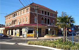
 Earlwood Hotel, Homer Street in 2006 | |||||||||||||||
 | |||||||||||||||
| Population | 18,053 (2021 census)[1] | ||||||||||||||
| Established | 1829 | ||||||||||||||
| Postcode(s) | 2206 | ||||||||||||||
| Elevation | 51 m (167 ft) | ||||||||||||||
| Location | 10 km (6 mi) SW of Sydney CBD | ||||||||||||||
| LGA(s) | City of Canterbury-Bankstown | ||||||||||||||
| State electorate(s) | Canterbury | ||||||||||||||
| Federal division(s) | Barton | ||||||||||||||
| |||||||||||||||
Earlwood is a suburb of Sydney, in the state of New South Wales, Australia. Earlwood is located 10 kilometres south-west of the Sydney central business district, and is part of the Canterbury-Bankstown area. It is in the local government area of the City of Canterbury-Bankstown.[2]
Earlwood stretches from the southern bank of the Cooks River to the northern bank of Wolli Creek. Wolli Creek (the suburb), Turrella and Bardwell Park lie to the south across Wolli Creek, while Canterbury, Hurlstone Park and Marrickville are located to the north and east across Cooks River. The locality of Undercliffe is part of the suburb. Clemton Park adjoins the suburb to the west. Earlwood is primarily residential with some commercial developments around the main road, Homer Street.
- ^ Australian Bureau of Statistics (28 June 2022). "Earlwood (State Suburb)". 2021 Census QuickStats. Retrieved 13 August 2024.
- ^ NSW Geographical Names Board, Earlwood - Suburb