| Early Lake Erie | |
|---|---|
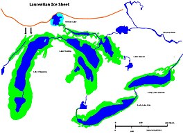
 Glacial Lakes Chippewa, Stanley, Early Erie and Early Ontario. Low-level lake stages during the end of the Wisconsin Glacial era in North America. Based on Larsen map, 1987. | |
| Location | North America |
| Group | Great Lakes |
| Coordinates | 42°36′N 79°42′W / 42.6°N 79.7°W |
| Lake type | former lake |
| Etymology | Lake Erie from the Erie Indians |
| Primary inflows | Detroit River |
| Primary outflows | Niagara River Welland Canal |
| Basin countries | Canada United States |
| First flooded | 13,000 years before present |
| Max. length | 241 mi (388 km) |
| Max. width | 57 mi (92 km) |
| Residence time | 300 years in existence |
| Surface elevation | 476 ft (145 m)[1] |
| References | Lewis CFM, Cameron GDM, Anderson TW, Heil CW Jr, Gareau PL. 2012. Lake levels in the Erie Basin of the Laurentian Great Lakes. Journal of Paleolimnology 47:493-511. |
Early Lake Erie was a prehistoric proglacial lake that existed at the end of the last ice age approximately 13,000 years ago. The early Erie fed waters to Glacial Lake Iroquois.
The ancient lake was similar in size to the current lake during glacial retreat, but for some period the eastern half of the lake was covered with ice.
Early-period Lake Erie was made up of smaller lakes (Lakes Warren, Wayne, Maumee and Lundy) with lower depths. Much of the ancient lake bed is now northern Ohio.
- ^ Holcombe TL, Taylor LA, Reid DF, Warren JS, Vincent PA, Herdendorf CE. 2003. Revised Lake Erie postglacial lake level history based on new detailed bathymetry. Journal of Great Lakes Research *29:681-704.
