 | |
| Mission type | Earth observation |
|---|---|
| Operator | NASA / GSFC |
| COSPAR ID | 2000-075A |
| SATCAT no. | 26619 |
| Website | eo1 |
| Mission duration | Planned: 1 year Final: 16 years, 4 months, 8 days |
| Spacecraft properties | |
| Manufacturer | Swales Aerospace Northrop Grumman |
| Launch mass | 573 kg (1,263 lb) |
| Start of mission | |
| Launch date | 21 November 2000, 18:24:25 UTC[1] |
| Rocket | Delta II 7320-10C, D282[1] |
| Launch site | Vandenberg SLC-2W |
| End of mission | |
| Disposal | Decommissioned |
| Deactivated | 30 March 2017 |
| Decay date | 2056 (planned) |
| Orbital parameters | |
| Reference system | Geocentric |
| Regime | Sun-synchronous |
| Semi-major axis | 7,058 km (4,386 mi) |
| Eccentricity | 0.00071 |
| Perigee altitude | 690 km (430 mi) |
| Apogee altitude | 700 km (430 mi) |
| Inclination | 98.21 degrees |
| Period | 98.7 minutes |
| Epoch | 21 November 2000, 08:24:00 UTC[2] |
| Instruments | |
| Advanced Land Imager (ALI) Hyperspectral Imager (Hyperion) Atmospheric Corrector | |
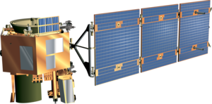
Earth Observing-1 (EO-1) was a NASA Earth observation satellite created to develop and validate a number of instrument and spacecraft bus breakthrough technologies. It was intended to enable the development of future Earth imaging observatories that will have a significant increase in performance while also having reduced cost and mass. The spacecraft was part of the New Millennium Program. It was the first satellite to map active lava flows from space; the first to measure a facility's methane leak from space; and the first to track re-growth in a partially logged Amazon forest from space. EO-1 captured scenes such as the ash after the World Trade Center attacks, the flooding in New Orleans after Hurricane Katrina, volcanic eruptions and a large methane leak in southern California.[3]
- ^ a b Ray, Justin (22 November 2000). "Delta 2 rocket puts three satellites into Earth orbit". Spaceflight Now. Archived from the original on 18 April 2022. Retrieved 14 April 2017.
- ^ "EO 1 - Trajectory Details". National Space Science Data Center. NASA. Archived from the original on 18 April 2022. Retrieved 14 April 2017.
- ^ "NASA says goodbye to Earth Observing-1 (EO-1) satellite after 17 years". 17 March 2017. Archived from the original on 18 April 2022. Retrieved 14 December 2017.