East Amwell Township, New Jersey | |
|---|---|
 | |
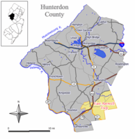
 Location of East Amwell Township in Hunterdon County highlighted in yellow (right). Inset map: Location of Hunterdon County in New Jersey highlighted in black (left). | |
 Census Bureau map of East Amwell Township, New Jersey | |
Location in Hunterdon County Location in New Jersey | |
| Coordinates: 40°26′06″N 74°49′23″W / 40.434992°N 74.82303°W[1][2] | |
| Country | |
| State | |
| County | |
| Incorporated | April 6, 1846 |
| Named for | Amwell Township / Great and Little Amwell, Hertfordshire |
| Government | |
| • Type | Township (New Jersey) |
| • Body | Township Committee |
| • Mayor | Jenna Casper-Bloom (D, term ends December 31, 2023)[3][4] |
| • Municipal clerk | Linda Giliberti[5] |
| Area | |
• Total | 28.56 sq mi (73.96 km2) |
| • Land | 28.46 sq mi (73.70 km2) |
| • Water | 0.10 sq mi (0.27 km2) 0.36% |
| • Rank | 94th of 565 in state 8th of 26 in county[1] |
| Elevation | 203 ft (62 m) |
| Population | |
• Total | 3,917 |
• Estimate (2023)[9] | 3,937 |
| • Rank | 416th of 565 in state 12th of 26 in county[10] |
| • Density | 137.7/sq mi (53.2/km2) |
| • Rank | 527th of 565 in state 24th of 26 in county[10] |
| Time zone | UTC−05:00 (Eastern (EST)) |
| • Summer (DST) | UTC−04:00 (Eastern (EDT)) |
| ZIP Code | |
| Area code(s) | 609 and 908[13] |
| FIPS code | 3401918820[1][14][15] |
| GNIS feature ID | 0882180[1][16] |
| Website | www |
East Amwell Township is a township in Hunterdon County, in the U.S. state of New Jersey. As of the 2020 United States census, the township's population was 3,917,[8] a decrease of 96 (−2.4%) from the 2010 census count of 4,013,[17][18] which in turn reflected a decline of 442 (−9.9%) from the 4,455 counted in the 2000 census.[19]
East Amwell Township is located in the southeastern corner of Hunterdon County where it borders both Somerset and Mercer counties, within the heart of the Amwell Valley and Raritan Valley regions. It includes the unincorporated community of Ringoes, the oldest known settlement in Hunterdon County, as well as the communities of Larison's Corner, Weert's Corner and part of Reaville.[20]
- ^ a b c d e 2019 Census Gazetteer Files: New Jersey Places, United States Census Bureau. Accessed July 1, 2020.
- ^ US Gazetteer files: 2010, 2000, and 1990, United States Census Bureau. Accessed September 4, 2014.
- ^ Cite error: The named reference
Officialswas invoked but never defined (see the help page). - ^ 2023 New Jersey Mayors Directory, New Jersey Department of Community Affairs, updated February 8, 2023. Accessed February 10, 2023.
- ^ Township Clerk, Township of East Amwell. Accessed March 8, 2023.
- ^ Cite error: The named reference
DataBookwas invoked but never defined (see the help page). - ^ U.S. Geological Survey Geographic Names Information System: Township of East Amwell, Geographic Names Information System. Accessed March 5, 2013.
- ^ a b Cite error: The named reference
LWD2020was invoked but never defined (see the help page). - ^ Cite error: The named reference
PopEstwas invoked but never defined (see the help page). - ^ a b Population Density by County and Municipality: New Jersey, 2020 and 2021, New Jersey Department of Labor and Workforce Development. Accessed March 1, 2023.
- ^ Look Up a ZIP Code for Ringoes, NJ, United States Postal Service. Accessed November 14, 2012.
- ^ Look Up a ZIP Code for Stockton, NJ, United States Postal Service. Accessed November 14, 2012.
- ^ Area Code Lookup - NPA NXX for Ringoes, NJ, Area-Codes.com. Accessed September 3, 2013.
- ^ U.S. Census website, United States Census Bureau. Accessed September 4, 2014.
- ^ Geographic Codes Lookup for New Jersey, Missouri Census Data Center. Accessed April 1, 2022.
- ^ US Board on Geographic Names, United States Geological Survey. Accessed September 4, 2014.
- ^ Cite error: The named reference
Census2010was invoked but never defined (see the help page). - ^ Cite error: The named reference
LWD2010was invoked but never defined (see the help page). - ^ Table 7. Population for the Counties and Municipalities in New Jersey: 1990, 2000 and 2010, New Jersey Department of Labor and Workforce Development, February 2011. Accessed May 1, 2023.
- ^ Demographics Archived 2012-07-16 at the Wayback Machine, Township of East Amwell. Accessed November 14, 2012. "East Amwell is at the base of the Sourland Mountains. Its 28.68 square miles encompasses the communities of Ringoes, Weert's Corner, Larison's Corner and a portion of Reaville."


