| East Dundry | |
|---|---|
 East Dundry in about 2010 | |
Location within Somerset | |
| OS grid reference | ST575662 |
| Unitary authority | |
| Ceremonial county | |
| Region | |
| Country | England |
| Sovereign state | United Kingdom |
| Post town | BRISTOL |
| Postcode district | BS41 |
| Dialling code | 0117 |
| Police | Avon and Somerset |
| Fire | Avon |
| Ambulance | South Western |
| UK Parliament | |


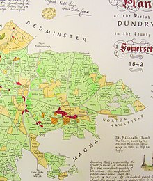
East Dundry is a south-facing hamlet some 160 metres above sea level in a sheltered valley of Dundry Hill just south of Bristol, England. The hamlet is in the parish of Dundry and about two kilometres east of its village church. The iron-age Maes Knoll tump (2.5 kilometres to the east) and tumuli (in the field just north-east of North Hill Farm) are evidence of long occupation of the valley.
