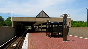
 East Falls Church station's platform facing west in May 2010 | ||||||||||||||||
| General information | ||||||||||||||||
| Location | Arlington County, Virginia, U.S. | |||||||||||||||
| Coordinates | 38°53′10″N 77°09′25″W / 38.8859763°N 77.1568243°W | |||||||||||||||
| Owned by | Washington Metropolitan Area Transit Authority | |||||||||||||||
| Platforms | 1 island platform | |||||||||||||||
| Tracks | 2 | |||||||||||||||
| Bus stands | 4 | |||||||||||||||
| Connections |
| |||||||||||||||
| Construction | ||||||||||||||||
| Structure type | At-grade | |||||||||||||||
| Parking | 422 spaces | |||||||||||||||
| Bicycle facilities | Capital Bikeshare, 12 racks, 6 lockers, secure parking room | |||||||||||||||
| Accessible | Yes | |||||||||||||||
| Other information | ||||||||||||||||
| Station code | K05 | |||||||||||||||
| History | ||||||||||||||||
| Opened | June 7, 1986 | |||||||||||||||
| Rebuilt | 2020 | |||||||||||||||
| Passengers | ||||||||||||||||
| 2023 | 1,891 daily[1] | |||||||||||||||
| Rank | 53 out of 98 | |||||||||||||||
| Services | ||||||||||||||||
| ||||||||||||||||
| ||||||||||||||||
East Falls Church station is an island platformed Washington Metro station in Arlington County, Virginia, on the Orange and Silver Lines. East Falls Church station is the last aboveground, at-grade, or open-cut station for eastbound trains until Minnesota Avenue. East of this station, the trains enter tunnels.
The station serves the communities of Falls Church, Seven Corners, and Arlington. It is located in the median of Interstate 66 near Lee Highway (U.S. Route 29). Service began on June 7, 1986. A parking lot with 422 spaces sits on the Lee Highway side of the station.
- ^ "Metrorail Ridership Summary". Washington Metropolitan Area Transit Authority. Retrieved February 10, 2024.
