East Honolulu | |
|---|---|
 | |
| Coordinates: 21°17′20″N 157°43′2″W / 21.28889°N 157.71722°W | |
| Country | |
| State | |
| Counties | Honolulu |
| Area | |
• Total | 34.45 sq mi (89.24 km2) |
| • Land | 23.01 sq mi (59.58 km2) |
| • Water | 11.45 sq mi (29.65 km2) |
| Population (2020) | |
• Total | 50,922 |
| • Density | 2,213.42/sq mi (854.61/km2) |
| Time zone | UTC-10 |
| Area code | 808 |
| GNIS feature ID | 2583416[2] |
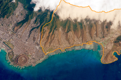
East Honolulu is a census-designated place (CDP) located in Honolulu County, Hawaii, United States. As of the 2020 Census, the CDP had a population of 50,922, making it the 2nd most populated CDP in Hawaii, behind Honolulu.[3]
- ^ "2020 U.S. Gazetteer Files". United States Census Bureau. Retrieved December 18, 2021.
- ^ "East Honolulu Census Designated Place". Geographic Names Information System. United States Geological Survey, United States Department of the Interior. Retrieved December 29, 2013.
- ^ "Profile of General Population and Housing Characteristics: 2010 Demographic Profile Data (DP-1): East Honolulu CDP, Hawaii". United States Census Bureau. Retrieved May 17, 2012.