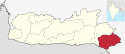
East Jaintia Hills district
Pait Wah | |
|---|---|
 Lukha River | |
 Location in Meghalaya | |
| Country | |
| State | Meghalaya |
| Headquarters | Khliehriat |
| Government | |
| • Vidhan Sabha constituencies | 3 |
| Area | |
| • Total | 2,040 km2 (790 sq mi) |
| Population (2011) | |
| • Total | 122,939 |
| • Density | 60/km2 (160/sq mi) |
| Demographics | |
| • Literacy | 53% |
| Time zone | UTC+05:30 (IST) |
| Major highways | NH-6 |
| Website | eastjaintiahills |
East Jaintia Hills district is a district with its headquarters at Khliehriat in Meghalaya state of India. The district was carved out of Jaintia Hills district on 31 July 2012.
Khliehriat and Saipung are the two community and rural development (C&RD) blocks of the district.[1]
