East Nantmeal Township | |
|---|---|
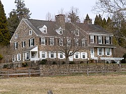
 Warwick Farmhouse, part of a historic district in the township of Warwick, neighboring East Nantmeal | |
 Location of East Nantmeal Township in Chester County, Pennsylvania and the state of Pennsylvania | |
 Location of Pennsylvania in the United States | |
| Coordinates: 40°07′00″N 75°43′59″W / 40.11667°N 75.73306°W | |
| Country | United States |
| State | Pennsylvania |
| County | Chester |
| Area | |
• Total | 16.38 sq mi (42.43 km2) |
| • Land | 16.21 sq mi (41.99 km2) |
| • Water | 0.17 sq mi (0.44 km2) |
| Elevation | 617 ft (188 m) |
| Population | |
• Total | 1,832 |
• Estimate (2023)[2] | 1,854 |
| • Density | 113.56/sq mi (43.85/km2) |
| Time zone | UTC-5 (EST) |
| • Summer (DST) | UTC-4 (EDT) |
| Area code(s) | 610 |
| FIPS code | 42-029-21576 |
East Nantmeal Township is a township in Chester County, Pennsylvania, United States. The population was 1,832 at the 2020 census. Along with West Nantmeal Township, it was originally part of a single Nantmeal Township, which was divided in 1739.
- ^ "2016 U.S. Gazetteer Files". United States Census Bureau. Retrieved Aug 13, 2017.
- ^ a b Bureau, US Census. "City and Town Population Totals: 2020-2023". Census.gov. US Census Bureau. Retrieved November 18, 2024.
{{cite web}}:|last1=has generic name (help)