East Renfrewshire Aest Renfrewshire Siorrachd Rinn Friù an Ear | |
|---|---|
 | |
 | |
| Coordinates: 55°47′54″N 4°17′27″W / 55.7984°N 4.2907°W | |
| Sovereign state | United Kingdom |
| Country | Scotland |
| Lieutenancy area | Renfrewshire |
| Admin HQ | Giffnock |
| Government | |
| • Body | East Renfrewshire Council |
| • Control | Labour + Independent (council Independent / Labour) |
| • MPs | Blair McDougall (Labour – East Renfrewshire) |
| • MSPs | • Jackson Carlaw (Conservative – Eastwood) • Tom Arthur (SNP – Renfrewshire South) |
| Area | |
| • Total | 67 sq mi (174 km2) |
| • Rank | Ranked 28th |
| Population (2022) | |
| • Total | 97,160 |
| • Rank | Ranked 22nd |
| • Density | 1,400/sq mi (560/km2) |
| ONS code | S12000011 |
| ISO 3166 code | GB-ERW |
| Website | www |

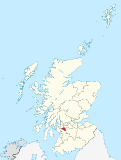
East Renfrewshire (Scots: Aest Renfrewshire; Scottish Gaelic: Siorrachd Rinn Friù an Ear) is one of 32 council areas of Scotland. It was formed in 1996, as a successor to the Eastwood district of the Strathclyde region. The northeastern part of the council area is close to Glasgow and many of the council area's northern settlements fall into the Greater Glasgow urban area.
Clockwise, East Renfrewshire borders Glasgow City council area to the northeast, South Lanarkshire to the southeast, East Ayrshire to the southwest, North Ayrshire to the west and Renfrewshire to the northwest.
Until 1975, the council area formed part of the county of Renfrewshire for local government purposes along with the modern council areas of Renfrewshire and Inverclyde. These three council areas together still form a single lieutenancy area called Renfrewshire.
