| East River | |
|---|---|
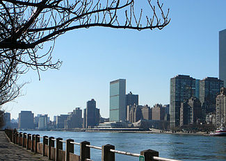
 East River (foreground) and the headquarters of the United Nations in Manhattan (background) seen from Roosevelt Island in December 2006 | |
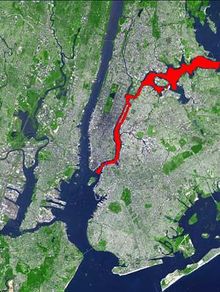
 Aerial map of New York City with the East River shown in red | |
| Location | |
| Country | United States |
| State | New York |
| Municipality | New York City |
| Physical characteristics | |
| Source | Long Island Sound |
| • coordinates | 40°48′00″N 73°47′06″W / 40.800°N 73.785°W |
| Mouth | Upper New York Bay |
• coordinates | 40°42′00″N 74°00′18″W / 40.700°N 74.005°W |
| Length | 16 mi (26 km) |
| Basin features | |
| Tributaries | |
| • left | Newtown Creek, Flushing River |
| • right | Westchester Creek, Bronx River, Bronx Kill, Harlem River |
 | |
The East River is a saltwater tidal estuary or strait in New York City. The waterway, which is not a river despite its name, connects Upper New York Bay on its south end to Long Island Sound on its north end. It separates Long Island, with the boroughs of Brooklyn and Queens, from Manhattan Island, and from the Bronx on the North American mainland.[1]
Because of its connection to Long Island Sound, it was once also known as the Sound River.[2] The tidal strait changes its direction of flow regularly, and is subject to strong fluctuations in its current, which are accentuated by its narrowness and variety of depths. The waterway is navigable for its entire length of 16 miles (26 km), and was historically the center of maritime activities in the city.[1][3]
- ^ a b Hodges, Godfrey. "East RIver" in Jackson, pp.393–93
- ^ Montrésor, John (1766). A plan of the city of New-York & its environs. London.
- ^ Cite error: The named reference
fed420was invoked but never defined (see the help page).