This article needs additional citations for verification. (May 2022) |
East Sussex | |
|---|---|
 | |
| Coordinates: 50°56′N 0°22′E / 50.94°N 0.37°E | |
| Sovereign state | United Kingdom |
| Constituent country | England |
| Region | South East England |
| Established | |
| Time zone | UTC+0 (GMT) |
| • Summer (DST) | UTC+1 (BST) |
| UK Parliament | 9 MPs |
| Ceremonial county | |
| Lord Lieutenant | Andrew Blackman CStJ (2021–)[1] |
| High Sheriff | Richard Bickersteth[2] (2023–24) |
| Area | 1,791 km2 (692 sq mi) |
| • Rank | 33rd of 48 |
| Population (2022)[3] | 828,685 |
| • Rank | 30th of 48 |
| Density | 463/km2 (1,200/sq mi) |
| Ethnicity |
|
| Non-metropolitan county | |
| County council | East Sussex County Council |
| Control | Conservative |
| Admin HQ | Lewes |
| Area | 1,709 km2 (660 sq mi) |
| • Rank | 19th of 21 |
| Population (2022)[4] | 550,720 |
| • Rank | 21st of 21 |
| Density | 322/km2 (830/sq mi) |
| ISO 3166-2 | GB-ESX |
| GSS code | E10000011 |
| ITL | TLJ22 |
| Website | eastsussex |
| Districts | |
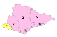
 Unitary County council area Districts of East Sussex | |
| Districts | |
East Sussex is a ceremonial county in South East England. It is bordered by Kent to the north-east, West Sussex to the west, Surrey to the north-west, and the English Channel to the south. The largest settlement is the city of Brighton and Hove, and the county town is Lewes.
The county has an area of 1,792 km2 (692 sq mi) and a population of 822,947.[5][6] The latter is largely concentrated along the coast, where the largest settlements are located: Brighton and Hove (277,105), Eastbourne (99,180), and Hastings (91,490).[7] The centre and north of the county are largely rural, and the largest settlement is Crowborough (21,990).[7] For local government purposes, East Sussex comprises a non-metropolitan county, with five districts, and the unitary authority of Brighton and Hove. East Sussex and West Sussex historically formed a single county, Sussex.
The north-east of East Sussex is part of the Weald, a sandstone anticline that was once an extensive woodland. The highest point in this area is Crowborough Hill (242 m (794 ft)), part of the High Weald uplands. The south-west of the county is part of the South Downs, a rolling chalk escarpment that stretches west into West Sussex and Hampshire. Ditchling Beacon (248 m (814 ft)) is the highest point. Where the downs reach the sea, they form high cliffs such as the Seven Sisters, where eroded dry valleys create an undulating skyline.[8] The county does not contain large rivers, but its largest are the Rother, which forms part of the boundary with Kent, the Cuckmere, and the Ouse, which rises in West Sussex and flows through Lewes before reaching the English Channel at Newhaven.[9]
- ^ "About the Lord Lieutenant – Personal Profile". Lieutenancy of East Sussex. Retrieved 3 March 2024.
- ^ "High Sheriff". Lieutenancy of East Sussex. Retrieved 3 March 2024.
- ^ "Mid-2022 population estimates by Lieutenancy areas (as at 1997) for England and Wales". Office for National Statistics. 24 June 2024. Retrieved 26 June 2024.
- ^ "Mid-Year Population Estimates, UK, June 2022". Office for National Statistics. 26 March 2024. Retrieved 3 May 2024.
- ^ "East Sussex County". Nomis. Archived from the original on 23 June 2023. Retrieved 4 December 2023.
- ^ "Brighton and Hove Local Authority". Nomis. Archived from the original on 5 December 2023. Retrieved 4 December 2023.
- ^ a b "Towns and cities, characteristics of built-up areas, England and Wales – Office for National Statistics". www.ons.gov.uk. Archived from the original on 21 November 2023. Retrieved 4 December 2023.
- ^ "East Sussex | Coastal Towns, Beaches, South Downs". Britannica. Archived from the original on 24 July 2023. Retrieved 24 July 2023.
- ^ . Encyclopædia Britannica. Vol. 26 (11th ed.). 1911. pp. 165–168.


