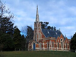
East Taieri | |
|---|---|
Settlement | |
 East Taieri Presbyterian Church | |
 | |
| Coordinates: 45°53′55″S 170°20′0″E / 45.89861°S 170.33333°E | |
| Country | New Zealand |
| Island | South Island |
| Region | Otago |
| District | Dunedin |
| Community board | Mosgiel-Taieri Community Board[1] |
| Electorates |
|
| Government | |
| • Territorial authority | Dunedin City Council |
| • Regional council | Otago Regional Council |
| • Mayor of Dunedin | Jules Radich |
| • Taieri MP | Ingrid Leary |
| • Te Tai Tonga MP | Tākuta Ferris |
| Area | |
| • Total | 3.13 km2 (1.21 sq mi) |
| Population (June 2023)[3] | |
| • Total | 2,460 |
| • Density | 790/km2 (2,000/sq mi) |
| Time zone | UTC+12 (NZST) |
| • Summer (DST) | UTC+13 (NZDT) |
| Area code | 03 |
| Local iwi | Ngāi Tahu |
East Taieri is a small township, located between Mosgiel and Allanton in New Zealand's Otago region. It lies on State Highway 1 en route between the city of Dunedin and its airport at Momona. It lies close to the southeastern edge of the Taieri Plain, hence its name.[4]
- ^ "2016 Mosgiel-Taieri Community Board Boundary" (PDF). dunedin.govt.nz. Dunedin City Council. Retrieved 2 June 2022.
- ^ Cite error: The named reference
Areawas invoked but never defined (see the help page). - ^ "Population estimate tables - NZ.Stat". Statistics New Zealand. Retrieved 25 October 2023.
- ^ Harriss, Gavin (November 2021). East Taieri, Otago (Map). NZ Topo Map.