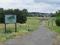
| East Wickham | |
|---|---|
 East Wickham Open Space | |
Location within Greater London | |
| Area | 0.83 sq mi (2.1 km2) |
| Population | 10,858 (2011)[1] |
| • Density | 13,082/sq mi (5,051/km2) |
| OS grid reference | TQ455765 |
| • Charing Cross | 10.5 mi (16.9 km) WNW |
| London borough | |
| Ceremonial county | Greater London |
| Region | |
| Country | England |
| Sovereign state | United Kingdom |
| Post town | WELLING |
| Postcode district | DA16 |
| Dialling code | 020 |
| Police | Metropolitan |
| Fire | London |
| Ambulance | London |
| UK Parliament | |
| London Assembly | |
East Wickham is a district in south-east London, England, within the London Borough of Bexley. It is situated north of Welling, east of Shooter's Hill, south of Plumstead, south-west of Abbey Wood and west of West Heath, and 10.5 miles (16.9 km) east-southeast of Charing Cross. Prior to the creation of Greater London in 1965, East Wickham was in the administrative county of Kent.
- ^ "East Wickham Ward - Local Area Report". Nomis. Office for National Statistics. Retrieved 4 January 2021.
