Oosterend
Easterein | |
|---|---|
Village | |
 Easterein, church: Martinikerk | |
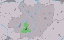
 Location in Littenseradiel municipality | |
| Coordinates: 53°5′47″N 5°37′6″E / 53.09639°N 5.61833°E | |
| Country | |
| Province | |
| Municipality | |
| Area | |
| • Total | 7.88 km2 (3.04 sq mi) |
| Elevation | 0.1 m (0.3 ft) |
| Population (2021)[1] | |
| • Total | 935 |
| • Density | 120/km2 (310/sq mi) |
| Postal code | 8734[1] |
| Dialing code | 0515 |
| Website | Official |
Easterein (Dutch: Oosterend) is a village in the municipality Súdwest-Fryslân in the province of Friesland, the Netherlands. It is southeast of Wommels and southwest of Itens, in the middle of Bolsward, Sneek, Leeuwarden and Franeker. The center is situated on the Oosterendervaart, which connects the Wijnsevaart and the Hidaardervaart with each other.
In 2019 the village had 970 residents. The village also includes the hamlets Driehuizen (uninhabited part) Meilahuizen and Schrok. Until 1955 Roodhuis was also part of Oosterend.
- ^ a b c "Kerncijfers wijken en buurten 2021". Central Bureau of Statistics. Retrieved 5 April 2022.
two entries
- ^ "Postcodetool for 8734GA". Actueel Hoogtebestand Nederland (in Dutch). Het Waterschapshuis. Retrieved 5 April 2022.


