| Eastern Continental Trail | |
|---|---|
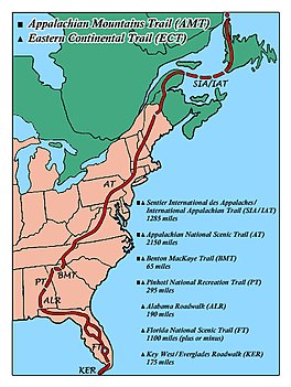
 Route of the Eastern Continental Trail through the eastern United States and Canada | |
| Length | 4,400 mi (7,100 km) |
| Location | Eastern United States and Canada |
| Trailheads | Key West, Florida Belle Isle (Newfoundland and Labrador) |
| Use | Hiking |
| Highest point | 6,643 ft (2,025 m), Kuwohi |
| Lowest point | Key West, Florida |
| Difficulty | Easy to strenuous |
| Season | Summer in northern sections, year round in southernmost sections |
| Sights | Appalachian Mountains Everglades Florida Keys Gaspé Peninsula Hudson Valley Lake Okeechobee Mount Katahdin Springer Mountain Amicalola Falls State Park Kuwohi McAfee Knob |
| Hazards | Alligators, American black bears, fire ants, limited water, tick-borne diseases, poison ivy, severe weather, steep grades, venomous snakes |
The Eastern Continental Trail (ECT) is a network of hiking trails in the United States and Canada, reaching from Key West, Florida to Belle Isle, Newfoundland and Labrador.