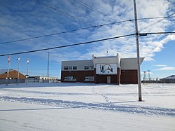
Eastmain
ᐄᔅᒣᐃᓐ (Îsmein) | |
|---|---|
Terre réservée crie (Cree reserved land) | |
 Wabannutao Eeyou School | |
| Coordinates: 52°15′N 78°30′W / 52.250°N 78.500°W[2] | |
| Country | Canada |
| Province | Quebec |
| Region | Nord-du-Québec |
| Territory | Eeyou Istchee |
| Formed | 1978 |
| Government | |
| • Chief | Raymond Shanoush |
| • Federal riding | Abitibi—Baie-James—Nunavik—Eeyou |
| • Provincial riding | Ungava |
| Area | |
• Total | 160.43 km2 (61.94 sq mi) |
| • Land | 148.99 km2 (57.53 sq mi) |
| Population | |
• Total | 924[1] |
| Time zone | UTC−05:00 (Within the AST legislated time zone boundary but observes EST[4]) |
| • Summer (DST) | UTC−04:00 (EDT) |
| Postal Code | J0M 1W0 |
| Area code(s) | 819 and 873 |
| Website | Eastmain.ca |
Eastmain (Quebec French pronunciation: [iːstˈmẽɪ̯̃]; Cree: ᐄᔅᒣᐃᓐ/Îsmein) is a Cree community located on east coast of James Bay at the mouth of the Eastmain River, Quebec, Canada. It is a small coastal Cree village with a population of 924 people in the 2021 Canadian Census up from 866 people at the 2016 Canadian Census.[1] Its alternate Cree name is ᐙᐸᓅᑖᐤ/Wâpanûtâw, meaning Lands east of James Bay.
Eastmain is accessible by air (Eastmain River Airport) and by car over a gravel road linking it to the James Bay Road, which takes around 1 hour.
The Eastmain community was greatly affected by the James Bay Project, which in 1980 diverted 90% of the Eastmain River to the La Grande River.
- ^ a b c "Data table, Census Profile, 2021 Census of Population - Eastmain, Terres réservées aux Cris (TC) [Census subdivision], Quebec". 9 February 2022.
- ^ "Banque de noms de lieux du Québec: Reference number 20121". toponymie.gouv.qc.ca (in French). Commission de toponymie du Québec.
- ^ "Répertoire des municipalités: Geographic code 99810". www.mamh.gouv.qc.ca (in French). Ministère des Affaires municipales et de l'Habitation.
- ^ National Research Council Canada – Time Zones & Daylight Saving Time Archived 17 March 2010 at the Wayback Machine

