| Eastmain | |
|---|---|
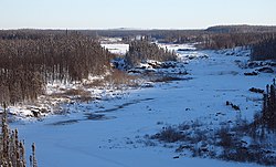
 Eastmain River in Dec. 2005 at the James Bay Road. | |
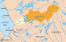
 Drainage basin of the Eastmain River. Current basin in yellow. Diverted basin to the La Grande River in orange. Original basin in yellow and orange. | |
| Location | |
| Country | Canada |
| Province | Quebec |
| Region | Jamésie |
| Physical characteristics | |
| Source | Lac Bréhat |
| • location | Baie-James, Nord-du-Québec, Québec, Canada |
| • coordinates | 52°31′30″N 70°52′00″W / 52.52500°N 70.86667°W |
| • elevation | 554 m (1,818 ft) |
| Mouth | James Bay |
• location | Eastmain, Nord-du-Québec, Quebec, Canada |
• coordinates | 52°14′30″N 78°34′00″W / 52.24167°N 78.56667°W |
• elevation | 0 m (0 ft) |
| Length | 756 km (470 mi)[1] |
| Basin size | 46,400 km2 (17,900 sq mi)[1] |
| Discharge | |
| • average | 930 m3/s (33,000 cu ft/s)[1] |
| Basin features | |
| Tributaries | |
| • left |
|
| • right |
|
The Eastmain River, formerly written East Main, is a river in west central Quebec. It rises in central Quebec and flows 800 km (500 mi) west to James Bay, draining an area of 46,400 km2 (17,900 sq mi). The First Nations Cree village of Eastmain is located beside the mouth.
- ^ a b c Atlas of Canada Archived February 2, 2007, at the Wayback Machine (all values of original river prior to hydro-electric development.)