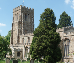
| Eaton Socon | |
|---|---|
 Eaton Socon church | |
Location within Cambridgeshire | |
| Area | 2.08 km2 (0.80 sq mi) |
| Population | 5,704 [1] |
| • Density | 2,742/km2 (7,100/sq mi) |
| OS grid reference | TL165595 |
| Civil parish | |
| District | |
| Shire county | |
| Region | |
| Country | England |
| Sovereign state | United Kingdom |
| Post town | ST NEOTS |
| Postcode district | PE19 |
| Dialling code | 01480 |
| Police | Cambridgeshire |
| Fire | Cambridgeshire |
| Ambulance | East of England |
| UK Parliament | |
Eaton Socon /iːtən soʊkən/ is a community in the civil parish of St Neots, in the Huntingdonshire district, in the county of Cambridgeshire, England. Eaton Socon is a component of the town of St Neots, located on its south-west margin. Eaton Socon lies on the west side of the River Great Ouse, and is bounded on the west by the A1 road and on the south by the A428 road (St Neots by-pass). On the north side Duloe Brook delineates the boundary with Eaton Ford, which is also part of St Neots.
Much of Eaton Socon is given over to residential use, but there is a large area dedicated to light industry and trade distribution activities. There are also several public houses and inns, and a retail park.
In the days of stagecoach travel, Eaton Socon was a major stop on the journey from London to the North, with inns providing refreshments and overnight accommodation for travellers, and feed and rest facilities for horses. Some stage coaches diverted through St Neots, but the majority continued on the Great North Road.
Eaton Socon was originally in Bedfordshire but it was merged with St Neots in 1965 and is now in Cambridgeshire. Its housing grew and its population more than doubled: 2,240 in 1931 to 3,264 in 1961, and now (2020) 9,042.
The name Eaton Socon comes from Ea-tun (waterside settlement) and soke (local government area in Norman times).
- ^ UK Census (2011). "Local Area Report – St Neots Eaton Socon Ward (E05002781)". Nomis. Office for National Statistics. Retrieved 20 December 2019.
