You can help expand this article with text translated from the corresponding article in German. (October 2012) Click [show] for important translation instructions.
|
Eberswalde | |
|---|---|
 | |
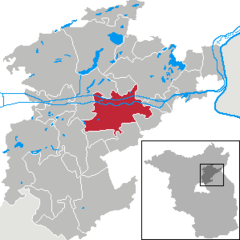
Location of Eberswalde within Barnim district  | |
| Coordinates: 52°50′N 13°50′E / 52.833°N 13.833°E | |
| Country | Germany |
| State | Brandenburg |
| District | Barnim |
| Subdivisions | 7 Ortsteile |
| Government | |
| • Mayor (2022–30) | Götz Herrmann SPD / Bfe[1] |
| Area | |
| • Total | 58.17 km2 (22.46 sq mi) |
| Elevation | 25 m (82 ft) |
| Population (2022-12-31)[2] | |
| • Total | 41,461 |
| • Density | 710/km2 (1,800/sq mi) |
| Time zone | UTC+01:00 (CET) |
| • Summer (DST) | UTC+02:00 (CEST) |
| Postal codes | 16225/16227 |
| Dialling codes | 03334 |
| Vehicle registration | BAR, BER, EW |
| Website | www.eberswalde.de |


Eberswalde (German pronunciation: [ˌʔeːbɐsˈvaldə] ) is a major town and the administrative seat of the district Barnim in Brandenburg in north-eastern Germany, about 50 km (31 mi) northeast of Berlin. Population 42,144 (census in June 2005), geographical location 52°50′N 13°50′E / 52.833°N 13.833°E. The town is often called Waldstadt (forest town), because of the large forests around it, including the Schorfheide-Chorin Biosphere Reserve. Despite this fact, Eberswalde was an important industrial center until the German Reunification.
- ^ Landkreis Barnim Wahl der Bürgermeisterin / des Bürgermeisters Archived 2023-05-12 at the Wayback Machine, accessed 10 November 2022.
- ^ "Bevölkerungsentwicklung und Bevölkerungsstandim Land Brandenburg Dezember 2022" (PDF). Amt für Statistik Berlin-Brandenburg (in German). June 2023.


