| Echuca Victoria | |||||||||||||||
|---|---|---|---|---|---|---|---|---|---|---|---|---|---|---|---|
 | |||||||||||||||
| Coordinates | 36°08′0″S 144°45′0″E / 36.13333°S 144.75000°E | ||||||||||||||
| Population | 15,056 (2021 census)[1] | ||||||||||||||
| • Density | 107.47/km2 (278.34/sq mi) | ||||||||||||||
| Postcode(s) | 3564 | ||||||||||||||
| Elevation | 96 m (315 ft) | ||||||||||||||
| Area | 140.1 km2 (54.1 sq mi) | ||||||||||||||
| Time zone | AEST (UTC+10) | ||||||||||||||
| • Summer (DST) | AEDT (UTC+11) | ||||||||||||||
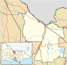
| Location |
| ||||||||||||||
| LGA(s) | Shire of Campaspe | ||||||||||||||
| County | Rodney | ||||||||||||||
| State electorate(s) | Murray Plains | ||||||||||||||
| Federal division(s) | Nicholls | ||||||||||||||
| |||||||||||||||
| |||||||||||||||
Echuca (/əˈtʃuːkə/ ə-CHOO-kə)[2] is a town on the banks of the Murray River and Campaspe River in Victoria, Australia. The border town of Moama is adjacent on the northern side of the Murray River in New South Wales. Echuca is the administrative centre and largest settlement in the Shire of Campaspe. As of the 2021 census, Echuca had a population of 15,056,[1] and the population of the combined Echuca and Moama townships was 22,568.[3]
Echuca lies within traditional Yorta Yorta country. The town's name is a Yorta Yorta word meaning "meeting of the waters".[4] Echuca is close to the junction of the Goulburn, Campaspe, and Murray Rivers. Its position at the closest point of the Murray to Melbourne contributed to its development as a thriving river port city during the 19th century.
- ^ a b Australian Bureau of Statistics (28 June 2022). "Echuca". 2021 Census QuickStats. Retrieved 14 November 2022.
- ^ Macquarie Dictionary, Fourth Edition (2005). Melbourne, The Macquarie Library Pty Ltd. ISBN 1-876429-14-3
- ^ Australian Bureau of Statistics (28 June 2022). "Echuca - Moama". 2021 Census QuickStats. Retrieved 14 November 2022.
- ^ "Proud past". Official website. Shire of Campaspe. Retrieved 19 April 2018.


