Edgard | |
|---|---|
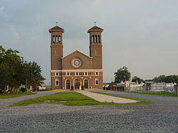
 St. John the Baptist Roman Catholic Church, Edgard | |
| Coordinates: 30°02′02″N 90°33′14″W / 30.03389°N 90.55389°W | |
| Country | United States |
| State | Louisiana |
| Parish | St. John the Baptist |
| Area | |
| • Total | 13.82 sq mi (35.81 km2) |
| • Land | 11.38 sq mi (29.49 km2) |
| • Water | 2.44 sq mi (6.32 km2) |
| Elevation | 13 ft (4 m) |
| Population (2020) | |
| • Total | 1,948 |
| • Density | 171.12/sq mi (66.07/km2) |
| Time zone | UTC-6 (CST) |
| • Summer (DST) | UTC-5 (CDT) |
| ZIP code | 70049 |
| Area code | 985 |
| FIPS code | 22-22815 |
Edgard is a census-designated place (CDP) in, and the parish seat of, St. John the Baptist Parish, Louisiana, United States.[2] The population was 2,637 at the 2000 census and 1,948 in 2020.[3] It is part of the New Orleans–Metairie–Kenner Metropolitan Statistical Area. Edgard is part of the German Coast of Louisiana.
- ^ "2020 U.S. Gazetteer Files". United States Census Bureau. Retrieved March 20, 2022.
- ^ "Find a County". National Association of Counties. Archived from the original on July 12, 2012. Retrieved June 7, 2011.
- ^ Cite error: The named reference
:0was invoked but never defined (see the help page).
