Edison, Washington | |
|---|---|
 Approaching the center of Edison from the south on Farm to Market Road | |
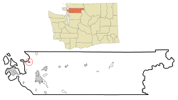
 Location of Edison, Washington | |
| Coordinates: 48°33′45″N 122°26′11″W / 48.56250°N 122.43639°W | |
| Country | United States |
| State | Washington |
| County | Skagit |
| Area | |
• Total | 0.6 sq mi (1.5 km2) |
| • Land | 0.6 sq mi (1.5 km2) |
| • Water | 0.0 sq mi (0.0 km2) |
| Elevation | 7 ft (2 m) |
| Population (2020) | |
• Total | 240 |
| • Density | 400/sq mi (160/km2) |
| Time zone | UTC-8 (Pacific (PST)) |
| • Summer (DST) | UTC-7 (PDT) |
| ZIP code | 98232 |
| Area code | 360 |
| FIPS code | 53-20680[1] |
| GNIS feature ID | 1519188[2] |
Edison is a census-designated place (CDP) in Skagit County, Washington, United States. The population was 240 at the 2020 census.[3] It is included in the Mount Vernon–Anacortes, Washington Metropolitan Statistical Area.
- ^ "U.S. Census website". United States Census Bureau. Retrieved January 31, 2008.
- ^ "US Board on Geographic Names". United States Geological Survey. October 25, 2007. Retrieved January 31, 2008.
- ^ "Census Bureau profile: Edison, Washington". United States Census Bureau. May 2023. Retrieved May 9, 2024.