Edison Park | |
|---|---|
| Community Area 09 - Edison Park | |
 Fieldhouse in Edison Park on the Northwest Highway | |
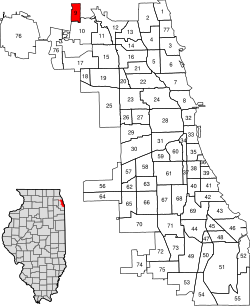
 Location within the city of Chicago | |
| Coordinates: 42°0.6′N 87°48.6′W / 42.0100°N 87.8100°W | |
| Country | United States |
| State | Illinois |
| County | Cook |
| City | Chicago |
| Neighborhoods | |
| Area | |
| • Total | 1.17 sq mi (3.03 km2) |
| Population (2020) | |
| • Total | 11,525 |
| • Density | 9,900/sq mi (3,800/km2) |
| Demographics 2015[1] | |
| • White | 87.32% |
| • Black | 1.07% |
| • Hispanic | 9.46% |
| • Asian | 1.46% |
| • Other | 0.70% |
| Educational Attainment 2015[1] | |
| • High School Diploma or Higher | 94.8% |
| • Bachelor's Degree or Higher | 46.3% |
| Time zone | UTC-6 (CST) |
| • Summer (DST) | UTC-5 (CDT) |
| ZIP Codes | part of 60631 |
| Median household income[2] | $86,300[1] |
| Source: U.S. Census, Record Information Services | |
Edison Park (formerly Canfield) is one of the 77 community areas of Chicago. It is located on the North Side, Chicago, Illinois, United States.
It consists entirely of the Edison Park neighborhood, and is named after Thomas Alva Edison,[3] who gave his blessing to this community namesake in 1890. According to the 2000 Census, its population is 11,259. Edison Park has one of the highest concentrations of Irish ancestry in Chicago, where they make up over three-fourths of the neighborhood's population.
Located between the Des Plaines River and the Chicago River, this area served as a local watershed divide. The Des Plaines River feeds into the Illinois River and the Mississippi River to reach the Gulf of Mexico. Like nearby Portage Park, Edison Park was a common portage for early travelers, who would carry their canoes across it.
- ^ a b c Cite error: The named reference
CMAP2016was invoked but never defined (see the help page). - ^ Paral, Rob. "Chicago Census Data". Archived from the original on 5 October 2013. Retrieved 22 September 2012.
- ^ Gannett, Henry (1905). The Origin of Certain Place Names in the United States. Govt. Print. Off. p. 114.