Edwards County | |
|---|---|
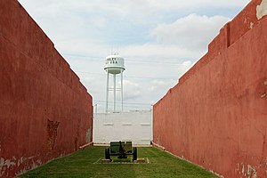
 Watertower in Kinsley (2009) | |
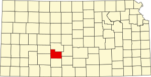
 Location within the U.S. state of Kansas | |
 Kansas's location within the U.S. | |
| Coordinates: 37°53′N 99°16′W / 37.883°N 99.267°W | |
| Country | |
| State | |
| Founded | March 18, 1874 |
| Named for | W. C. Edwards |
| Seat | Kinsley |
| Largest city | Kinsley |
| Area | |
• Total | 622 sq mi (1,610 km2) |
| • Land | 622 sq mi (1,610 km2) |
| • Water | 0.1 sq mi (0.3 km2) 0.01% |
| Population | |
• Total | 2,907 |
| • Density | 4.7/sq mi (1.8/km2) |
| Time zone | UTC−6 (Central) |
| • Summer (DST) | UTC−5 (CDT) |
| Area code | 620 |
| Congressional district | 4th |
| Website | edwardscounty.org |
Edwards County is a county located in the U.S. states of Kansas. Its county seat and most populous city is Kinsley.[2] As of the 2020 census, the county population was 2,907,[1] The county was founded in 1874 and named for W. C. Edwards, of Hutchinson, a pioneer settler who owned much land in the area.[3]
- ^ a b "QuickFacts; Edwards County, Kansas; Population, Census, 2020 & 2010". United States Census Bureau. Archived from the original on August 16, 2021. Retrieved August 16, 2021.
- ^ "Find a County". National Association of Counties. Archived from the original on July 12, 2012. Retrieved June 7, 2011.
- ^ Gannett, Henry (1905). The Origin of Certain Place Names in the United States. Govt. Print. Off. pp. 115.