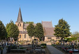
Eersel | |
|---|---|
 Eersel municipal hall | |
 Location in North Brabant | |
| Coordinates: 51°21′N 5°19′E / 51.350°N 5.317°E | |
| Country | Netherlands |
| Province | North Brabant |
| Government | |
| • Body | Municipal council |
| • Mayor | Wim Wouters |
| Area | |
• Total | 83.33 km2 (32.17 sq mi) |
| • Land | 82.46 km2 (31.84 sq mi) |
| • Water | 0.87 km2 (0.34 sq mi) |
| Elevation | 31 m (102 ft) |
| Population (January 2021)[3] | |
• Total | 19,528 |
| • Density | 237/km2 (610/sq mi) |
| Demonym | Eerselnaar |
| Time zone | UTC+1 (CET) |
| • Summer (DST) | UTC+2 (CEST) |
| Postcode | 5511–5525 |
| Area code | 040, 0497 |
| Website | www |


Eersel (Dutch pronunciation: [ˈeːrsəl] ) is a municipality and a town in southern Netherlands in the province of North Brabant. Eersel is situated in the Campine (Kempen) area.
Eersel is part of the Acht Zaligheden (Eight Beatitudes) and known for its attractive market. This market, together with the Hint, has been declared a protected village on 19 October 1967. This has been done to guarantee the future survival of its authentic character.
The spoken language is Kempenlands (an East Brabantian dialect, which is very similar to colloquial Dutch).[4]
- ^ "Kerncijfers wijken en buurten 2020" [Key figures for neighbourhoods 2020]. StatLine (in Dutch). CBS. 24 July 2020. Retrieved 19 September 2020.
- ^ "Postcodetool for 5521AW". Actueel Hoogtebestand Nederland (in Dutch). Het Waterschapshuis. Retrieved 11 May 2014.
- ^ "Bevolkingsontwikkeling; regio per maand" [Population growth; regions per month]. CBS Statline (in Dutch). CBS. 1 January 2021. Retrieved 2 January 2022.
- ^ Jos & Cor Swanenberg: Taal in stad en land: Oost-Brabants, ISBN 9012090105

