Eggner's Ferry Bridge | |
|---|---|
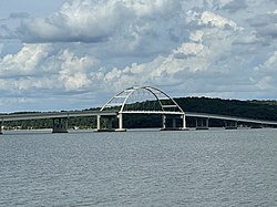
 The new Eggner's Ferry Bridge, viewed from the south in August 2022 | |
| Coordinates | 36°46′21″N 88°07′16″W / 36.772408°N 88.120995°W |
| Carries | 4 lanes of |
| Crosses | Kentucky Lake |
| Locale | Trigg and Marshall counties, Kentucky, United States |
| Maintained by | Kentucky Transportation Cabinet (KYTC) |
| Characteristics | |
| Design | Tied-arch bridge |
| Total length | 3,495 feet (1,065 m) |
| Longest span | 550 feet (170 m) |
| History | |
| Opened | March 25, 1932 (Original bridge) April 7, 2016 (Current bridge) |
| Closed | April 7, 2016 (Original bridge); Original structure demolished July 25, 2016 |
| Location | |
 | |
Eggner Ferry Bridge, also known as Eggner's Ferry Bridge, is a four-lane bridge in Trigg and Marshall counties in the U.S. state of Kentucky. The current through-arch bridge opened to traffic on April 7, 2016, replacing a two-lane bowstring truss bridge constructed in 1932. The bridge carries US 68 and Kentucky Route 80 across Kentucky Lake. The main span of the original 1932 bridge collapsed on January 26, 2012, after it was hit by a ship. There were no injuries. The bridge was repaired and reopened to traffic on May 25 of that year. On the morning of July 25, 2016, the middle four spans of the old Eggner's Ferry Bridge were brought down using controlled explosives.