This article has multiple issues. Please help improve it or discuss these issues on the talk page. (Learn how and when to remove these messages)
|
Ehingen | |
|---|---|
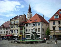
 Market square | |
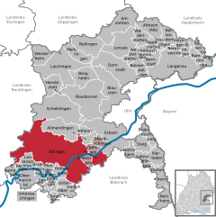
Location of Ehingen within Alb-Donau-Kreis district  | |
| Coordinates: 48°17′0″N 9°43′25″E / 48.28333°N 9.72361°E | |
| Country | Germany |
| State | Baden-Württemberg |
| Admin. region | Tübingen |
| District | Alb-Donau-Kreis |
| Subdivisions | 18 |
| Government | |
| • Lord mayor (2018–26) | Alexander Baumann[1] (CDU) |
| Area | |
| • Total | 178.40 km2 (68.88 sq mi) |
| Elevation | 515 m (1,690 ft) |
| Population (2022-12-31)[2] | |
| • Total | 27,276 |
| • Density | 150/km2 (400/sq mi) |
| Time zone | UTC+01:00 (CET) |
| • Summer (DST) | UTC+02:00 (CEST) |
| Postal codes | 89584 |
| Dialling codes | 07391 |
| Vehicle registration | UL |
| Website | www.ehingen.de |
Ehingen (Donau) (German pronunciation: [ˈeːhɪŋən]; Swabian: Eegne) is a town in the Alb-Donau district in Baden-Württemberg, Germany, situated on the left bank of the Danube, approx. 25 kilometres (16 miles) southwest of Ulm and 67 km (42 mi) southeast of Stuttgart.
The city, like the entire district of Ehingen, belonged to the French occupation zone from 1945 and initially came to the post-war state of Württemberg-Hohenzollern and from 1952 to the administrative region of South Württemberg-Hohenzollern in the new state of Baden-Württemberg.
- ^ Aktuelle Wahlergebnisse, Staatsanzeiger, accessed 11 September 2021.
- ^ "Bevölkerung nach Nationalität und Geschlecht am 31. Dezember 2022" [Population by nationality and sex as of December 31, 2022] (CSV) (in German). Statistisches Landesamt Baden-Württemberg. June 2023.


