Einabus | |
|---|---|
| Arabic transcription(s) | |
| • Arabic | عينابوس |
| • Latin | Ainabus (official) 'Aynabus (unofficial) |
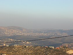
 In the front, beneath the telephone cable, is mount 725, an illegal Israeli outpost of Yitzhar. Beneath it, crossed by the telephone cable, is Einabus. Covering most of the farther area is the municipality of Qabalan. Behind the right side of Qabalan is Talfit, and behind it is Qaryut. Behind the middle of Qabalan is Ahijah. | |
Location of Einabus within Palestine | |
| Coordinates: 32°08′48″N 35°14′42″E / 32.14667°N 35.24500°E | |
| Palestine grid | 173/172 |
| State | State of Palestine |
| Governorate | Nablus |
| Government | |
| • Type | Village council (from 1996) |
| • Head of Municipality | Nafez Rashdan |
| Area | |
| • Total | 4,011 dunams (4.0 km2 or 1.5 sq mi) |
| Population (2017)[1] | |
| • Total | 2,891 |
| • Density | 720/km2 (1,900/sq mi) |
| Name meaning | "The spring of Abus"[2] |
Einabus (Arabic: عينابوس) is a Palestinian village in the northern West Bank, located 12 kilometers (7 miles) south of Nablus and a part of the Nablus Governorate. Nearby towns include Huwara and Beita to the east and Jammain to the south.[3]
- ^ Preliminary Results of the Population, Housing and Establishments Census, 2017 (PDF). Palestinian Central Bureau of Statistics (PCBS) (Report). State of Palestine. February 2018. pp. 64–82. Retrieved 2023-10-24.
- ^ Palmer, 1881, p. 221
- ^ About Einabus[permanent dead link] Einabus Village Council.
