Eixample | |
|---|---|
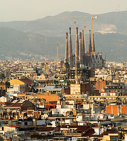
 Aerial view of the Eixample | |
 Location of the Eixample within Barcelona | |
| Coordinates: 41°23′27″N 2°09′47″E / 41.39083°N 2.16306°E | |
| Country | |
| Autonomous Community | |
| Province | Barcelona |
| Comarca | Barcelonès |
| Municipality | Barcelona |
| Neighborhoods | Fort Pienc, Sagrada Família, Dreta de l'Eixample, L'Antiga Esquerra de l'Eixample, La Nova Esquerra de l'Eixample, Sant Antoni |
| Area | |
• Total | 7.48 km2 (2.89 sq mi) |
| Population (2009) | |
• Total | 266,874 |
| • Density | 36,000/km2 (92,000/sq mi) |
| Demonym(s) | eixamplenc, -enca |
| Website | bcn.cat/eixample |
 | |


The Eixample (pronounced [əˈʃamplə]; Catalan for 'Expansion') is a district of Barcelona between the old city (Ciutat Vella) and what were once surrounding small towns (Sants, Gràcia, Sant Andreu, etc.), constructed in the 19th and early 20th centuries. Its population was 262,000 at the last census (2005).[1]
- ^ Variations in Population Density within Barcelona. Retrieved 18 September 2016