| Ejin River Heishui, Etsin-gol, Ruo He, Ruo Shui (弱水 (Chinese)) | |
|---|---|
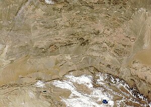
 Satellite view of the deserts of northern China. The Ruo River is visible as the faint green trace to the right of the image. | |
 | |
| Etymology | Named for the seasonal flows in its lower course |
| Native name | 额济纳河 (Chinese) |
| Location | |
| Country | China |
| State | Gansu, Inner Mongolia |
| City | Zhangye |
| Physical characteristics | |
| Source | Kan Chou and Hsü Chao springs |
| • location | Qilian Shan, Gansu |
| • coordinates | 38°00′04″N 100°54′45″E / 38.00111°N 100.91250°E |
| • elevation | 3,650 m (11,980 ft) |
| Mouth | Badain Jaran Playa |
• location | Badain Jaran Desert, Inner Mongolia |
• coordinates | 42°18′50″N 101°04′20″E / 42.31389°N 101.07222°E |
• elevation | 900 m (3,000 ft) |
| Length | 630 km (390 mi) |
| Basin size | 78,600 km2 (30,300 sq mi)approx. |
| Basin features | |
| Tributaries | |
| • left | Dang He, Beida He |
Ejin River (Chinese: 额济纳河), also Etsin Gol, Ruo Shui (Chinese: 弱水; lit. 'weak water', 'weak river') or Ruo He in ancient times, is a major river system of northern China. It flows approximately 630 kilometres (390 mi) from its headwaters on the northern Gansu side of the Qilian Mountains north-northeast into the endorheic Ejin Basin in the Gobi Desert. The river forms one of the largest inland deltas or alluvial fans in the world.[1] Its drainage basin covers about 78,600 square kilometres (30,300 sq mi) in parts of the Chinese provinces of Gansu and Inner Mongolia, which flows within the Zhangye area of Gansu; when it flows across Jiuquan area, it was renamed as Ruo Shui; when it flows across Alxa League, it is called Ejin River.