El Cerrito, California | |
|---|---|
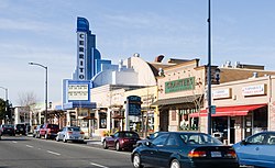
 Cerrito Theater on San Pablo Avenue | |
 Location of El Cerrito in Contra Costa County, California | |
| Coordinates: 37°54′57″N 122°18′42″W / 37.91583°N 122.31167°W | |
| Country | United States |
| State | California |
| County | Contra Costa |
| Incorporated | August 23, 1917[1] |
| Government | |
| • Mayor | Tessa Rudnick[2] |
| • State Senator | Nancy Skinner (D)[3] |
| • State Assembly | Buffy Wicks (D)[4] |
| • U. S. Congress | Mark DeSaulnier (D)[5] |
| • County Board | District 1: John Gioia |
| Area | |
| • Total | 3.67 sq mi (9.51 km2) |
| • Land | 3.67 sq mi (9.51 km2) |
| • Water | 0.00 sq mi (0.00 km2) 0% |
| Elevation | 69 ft (21 m) |
| Population | |
| • Total | 25,962 |
| • Density | 7,100/sq mi (2,700/km2) |
| Time zone | UTC-8 (PST) |
| • Summer (DST) | UTC-7 (PDT) |
| ZIP code | 94530 |
| Area code(s) | 510, 341 |
| FIPS code | 06-21796 |
| GNIS feature IDs | 277504, 2410410 |
| Website | www |
El Cerrito (Spanish for "The Little Hill") is a city in Contra Costa County, California, United States, and forms part of the San Francisco Bay Area. It has a population of 25,962 according to the 2020 census. El Cerrito was founded by refugees from the 1906 San Francisco earthquake. It was incorporated in 1917 as a village with 1,500 residents. As of the census in 2022, there were 25,583 people and 10,637 households in the city.[8]
- ^ "California Cities by Incorporation Date". California Association of Local Agency Formation Commissions. Archived from the original (Word) on November 3, 2014. Retrieved March 27, 2013.
- ^ "City Council". El Cerrito, CA. Retrieved March 21, 2013.
- ^ "Senators". State of California. Retrieved March 21, 2013.
- ^ "Members Assembly". State of California. Retrieved March 21, 2013.
- ^ "California's 10th Congressional District - Representatives & District Map". Civic Impulse, LLC. Retrieved October 13, 2024.
- ^ "2019 U.S. Gazetteer Files". United States Census Bureau. Retrieved July 1, 2020.
- ^ "El Cerrito (city) QuickFacts". United States Census Bureau. Retrieved July 14, 2021.
- ^ "U.S. Census Bureau".


