| El Pilar | |
|---|---|
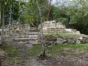
 Tzunu'un, a Maya house site surrounded by forest vegetation at El Pilar | |
 | |
| Location | Belize |
| Coordinates | 17°15′24″N 89°09′19″W / 17.25667°N 89.15528°W |
| Area | 20 km2 (7.7 sq mi) |
| Elevation | 200 m (660 ft) |
| Visitors | allowed |
El Pilar is an ancient Maya city center located on the Belize-Guatemala border. The site is located 12 kilometres (7.5 mi) north of San Ignacio, Belize and can be accessed through the San Ignacio and Bullet Tree Falls on the Belize River.[1] The name "El Pilar" is Spanish for "watering basin", reflecting the abundance of streams around the site and below its escarpment, which is rare in the Maya area.
The monuments of El Pilar are at the center of a 5,000 acres (2,000 ha) protected area known as El Pilar Archeological Reserve for Maya Flora and Fauna, declared a cultural monument in both Belize and Guatemala in 1998. El Pilar is the largest Maya site in the Belize River area with over 25 plazas and hundreds of other major buildings, covering about 120 acres (49 ha).[2][3]
- ^ "El Pilar Archaeological Reserve for Maya Flora and Fauna". Archived from the original on March 4, 2016. Retrieved September 25, 2015.
- ^ Estrada, Andrea (October 20, 2008). "Agreement Paves the Way for Archaeological Peace Park at El Pilar". Vol. 19, no. 4. University of California, Santa Barbara. 93106. Archived from the original on September 26, 2015. Retrieved September 25, 2015.
- ^ "List of 100 Most Endangered Sites 1996" (PDF). World Monuments Watch. Archived from the original (PDF) on March 20, 2013. Retrieved September 25, 2015.