| Reserva de la Biosfera El Pinacate y Gran Desierto de Altar | |
|---|---|
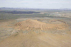
 Aerial view of El Pinacate y Gran Desierto de Altar Biosphere Reserve and adjacent volcano with black lava flows | |
 Location of the Reserve in Mexico | |
| Location | Sonora, Mexico |
| Nearest city | Puerto Peñasco Plutarco Elías Calles San Luis Río Colorado |
| Coordinates | 32°00′N 113°55′W / 32.000°N 113.917°W[1] |
| Area | 2,695.05 km2 (1,040.56 sq mi)[2] |
| Established | June 10, 1993 |
| Governing body | Instituto Nacional de Ecología and Tohono O'odham |
| elpinacate | |
| Official name | El Pinacate and Gran Desierto de Altar Biosphere Reserve |
| Type | Natural |
| Criteria | vii, viii, x |
| Designated | 2013 (37th session) |
| Reference no. | 1410 |
| Region | Latin America and the Caribbean |
| Official name | Agua Dulce |
| Designated | 2 February 2008 |
| Reference no. | 1813[3] |
El Pinacate and Gran Desierto de Altar Biosphere Reserve (Spanish: Reserva de la Biosfera El Pinacate y Gran Desierto de Altar) is a biosphere reserve and UNESCO World Heritage Site[1] managed by the federal government of Mexico, specifically by Secretariat of the Environment and Natural Resources, in collaboration with the state governments of Sonora and the Tohono O'odham.
It is in the Sonoran Desert in northwest Mexico, east of the Gulf of California, in the eastern part of the Gran Desierto de Altar, just south of the border with Arizona, United States and north of the city of Puerto Peñasco. It is one of the most significant visible landforms in North America seen from space. A volcanic system known as Santa Clara is the main part of the landscape, including three peaks: Pinacate, Carnegie and Medio. It is a sister park to Organ Pipe Cactus National Monument in Arizona.[4] Its wildlife is threatened by the militarization of the Mexico–United States border and the construction of the Mexico–United States border wall.[5]
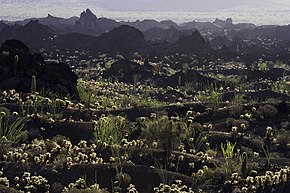
In the area there are over 540 species of plants, 40 species of mammals, 200 of birds, 40 of reptiles, amphibians and freshwater fishes.[6] There are threatened endemic species as Sonoran pronghorn, bighorn sheep, gila monster and desert tortoise.[7]
The biosphere reserve covers an area of 2,695.05 square kilometres (1,040.56 sq mi),[2] making up about half of the World Heritage site. The extent of the World Heritage site is 7,146 km²,[8][9] greater than that of the states of Aguascalientes, Colima, Morelos and Tlaxcala separated.[10]
- ^ a b UNESCO. "El Pinacate and Gran Desierto de Altar Biosphere Reserve". Retrieved June 24, 2013.
- ^ a b "El Pinacate y Gran Desierto de Altar Biosphere Reserve". Retrieved 15 June 2018.
- ^ "Agua Dulce". Ramsar Sites Information Service. Retrieved 25 April 2018.
- ^ "El Pinacate y Gran Desierto de Altar - Organ Pipe Cactus National Monument". U.S. National Park Service. Retrieved 2023-12-03.
- ^ "What a Border Wall Could Mean for Wildlife | Audubon". www.audubon.org. Retrieved 2023-12-03.
- ^ Comisión Nacional de Áreas Naturales Protegidas. "Reserva de la Biosfera El Pinacate y Gran Desierto de Altar". Archived from the original on August 12, 2016. Retrieved September 29, 2010.
- ^ Red Escolar. "Reserva de la Biosfera El Pinacate y Gran Desierto de Altar". Archived from the original on November 21, 2010. Retrieved September 29, 2010.
- ^ Comisión Nacional para el Conocimiento y Uso de la Biodiversidad. "Regiones terrestres prioritarias de México" (PDF). Retrieved September 29, 2010.
- ^ "El Pinacate y Gran Desierto de Altar World Heritage Site". Retrieved 15 June 2018.
- ^ INEGI. "Información por entidad". Archived from the original on 2011-07-23.

