El Rosal | |
|---|---|
Municipality and town | |
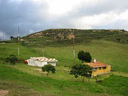
 Seismological station in El Rosal | |
 Location of the municipality and town inside Cundinamarca Department of Colombia | |
| Coordinates: 4°51′7″N 74°15′46″W / 4.85194°N 74.26278°W | |
| Country | |
| Department | |
| Province | Western Savanna Province |
| Founded | 28 March 1903 |
| Founded by | Ana Vicenta González |
| Government | |
| • Mayor | Hugo Orlando Arévalo Pulído (2016-2019) |
| Area | |
| • Municipality and town | 87.21 km2 (33.67 sq mi) |
| • Urban | 0.95 km2 (0.37 sq mi) |
| Elevation | 2,685 m (8,809 ft) |
| Population (2018 census)[1] | |
| • Municipality and town | 22,065 |
| • Density | 250/km2 (660/sq mi) |
| • Urban | 18,958 |
| • Urban density | 20,000/km2 (52,000/sq mi) |
| Time zone | UTC-5 (Colombia Standard Time) |
| Website | Official website |
El Rosal (Spanish pronunciation: [el roˈsal]) is a municipality and town of Colombia in the Western Savanna Province, part of the department of Cundinamarca. El Rosal is situated on the Bogotá savanna with its urban centre at an altitude of 2,685 metres (8,809 ft) and a distance of 20 kilometres (12 mi) from the capital Bogotá. It is part of the Metropolitan Area of Bogotá. El Rosal borders Subachoque in the northeast, San Francisco in the northwest, Madrid in the southeast and Facatativá in the southwest.[2]
- ^ Citypopulation.de
- ^ (in Spanish) Official website El Rosal

