Elden | |
|---|---|
Village | |
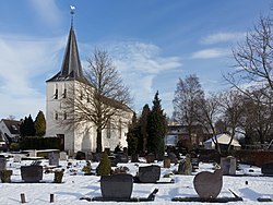
 Elden, church: Bonifaciuskerk | |
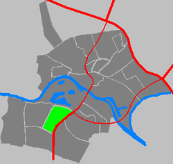
 Location in Arnhem | |
| Coordinates: 51°58′N 5°53′E / 51.967°N 5.883°E | |
| Country | Netherlands |
| Province | Gelderland |
| Municipality | Arnhem |
| Area | |
| • Total | 1.87 km2 (0.72 sq mi) |
| Elevation | 10 m (30 ft) |
| Population (2021)[1] | |
| • Total | 2,865 |
| • Density | 1,500/km2 (4,000/sq mi) |
| Time zone | UTC+1 (CET) |
| • Summer (DST) | UTC+2 (CEST) |
| Postal code | 6842[1] |
| Dialing code | 026 |
Elden is a village in the Dutch province of Gelderland. It is located in the municipality of Arnhem, about 4 km southwest of the city centre.
Elden was a separate municipality between 1813 and 1818, when it was merged with Elst.[3] It became part of Arnhem in 1966.[4]
The village of Elden, on the south side of the Rhine, has now been completely surrounded by neighbourhoods of the city of Arnhem and is now an enclave. The village still has its own place name signs.[4]
- ^ a b c "Kerncijfers wijken en buurten 2021". Central Bureau of Statistics. Retrieved 13 April 2022.
- ^ "Postcodetool for 6842AA". Actueel Hoogtebestand Nederland (in Dutch). Het Waterschapshuis. Retrieved 13 April 2022.
- ^ Ad van der Meer and Onno Boonstra, Repertorium van Nederlandse gemeenten, KNAW, 2011.
- ^ a b "Elden". Plaatsengids (in Dutch). Retrieved 13 April 2022.


