Eldorado, Texas | |
|---|---|
 Eldorado welcome sign | |
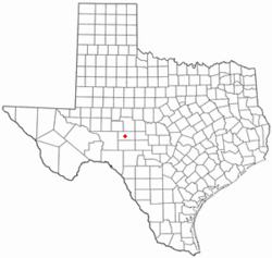
 Location of Eldorado, Texas | |
 | |
| Coordinates: 30°51′39″N 100°35′54″W / 30.86083°N 100.59833°W | |
| Country | United States |
| State | Texas |
| County | Schleicher |
| Government | |
| • Type | Mayor–council |
| • Body | City Council |
| • Mayor | George Arispe |
| Area | |
• Total | 1.39 sq mi (3.61 km2) |
| • Land | 1.39 sq mi (3.61 km2) |
| • Water | 0.00 sq mi (0.00 km2) |
| Elevation | 2,438 ft (743 m) |
| Population (2020) | |
• Total | 1,574 |
| • Density | 1,100/sq mi (440/km2) |
| Time zone | UTC-6 (Central (CST)) |
| • Summer (DST) | UTC-5 (CDT) |
| ZIP code | 76936 |
| Area code | 325 |
| FIPS code | 48-22960[2] |
| GNIS feature ID | 1356891[3] |
| Website | http://www.eldoradotexas.us/ |
Eldorado (/ˌɛldəˈrɑːdoʊ/ EL-də-RAH-doh, /-ˈreɪdoʊ/ -RAY-doh) is the only city in and the county seat of Schleicher County, Texas, United States.[4] The population was 1,574 at the 2020 census.[5] Eldorado is located on U.S. Highway 277, some 21 miles (34 km) north of Sonora and 43 miles (69 km) south of San Angelo, Texas.
- ^ "2019 U.S. Gazetteer Files". United States Census Bureau. Retrieved August 7, 2020.
- ^ "U.S. Census website". United States Census Bureau. Retrieved January 31, 2008.
- ^ "US Board on Geographic Names". United States Geological Survey. October 25, 2007. Retrieved January 31, 2008.
- ^ "Find a County". National Association of Counties. Archived from the original on May 31, 2011. Retrieved June 7, 2011.
- ^ Cite error: The named reference
:0was invoked but never defined (see the help page).