| Clarence New South Wales—Legislative Assembly | |||||||||||||||
|---|---|---|---|---|---|---|---|---|---|---|---|---|---|---|---|
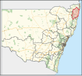
Interactive map of district boundaries from the 2023 state election | |||||||||||||||
| State | New South Wales | ||||||||||||||
| Dates current | 1859–1920 1927–present | ||||||||||||||
| MP | Richie Williamson | ||||||||||||||
| Party | The Nationals | ||||||||||||||
| Namesake | Clarence River | ||||||||||||||
| Electors | 57,265 (2023) | ||||||||||||||
| Area | 13,494.54 km2 (5,210.3 sq mi) | ||||||||||||||
| Demographic | Rural | ||||||||||||||
| |||||||||||||||
Clarence is an electoral district of the Legislative Assembly in the Australian state of New South Wales.
It includes all of the Clarence Valley Council including Grafton, Maclean, Yamba, Illuka, Junction Hill, Ulmarra, Coutts Crossing and Glenreagh, as well as all of the Richmond Valley Council including Casino, Coraki, Woodburn, Evans Head and Tatham.[1]
- ^ "Clarence". New South Wales Electoral Commission. Retrieved 23 November 2019.

